(sometimes we provide two download links because it may happen that the main server / link is overloaded or slow or non responding - the files are identical. Just choose one, save to the Desktop, double click to install)
Disclaimer: to our best knowledge this download comes from a website that is
safe (the last time we checked it, it was), but for your peace of mind (and better safe than sorry) we advise you to run an
antivirus on the downloaded file. Do not rely on MSWindows, Internet explorer, or on the electronic signature: a unsigned download is usually as safe as a signed one, signed just means the author paid Microsoft or Verisign for a stamp, it does not mean verified. Please kindly
report us problems with detail (click here to report), if any.
GeoDLL supports the development of geodetic software on various platforms by providing geodetic functions. GeoDLL contains precise calculations on the themes 2D and 3D coordinate transformation, geodetic datum shift and reference system converting, meridian strip changing, user defined coordinate and reference systems, distance calculations, Digital Elevation Model, NTv2 handling and BeTA2007 support, Direct / Inverse solutions and much more.
(
DLL with geodesic functions for2D and 3D coordinate transformations and more.)
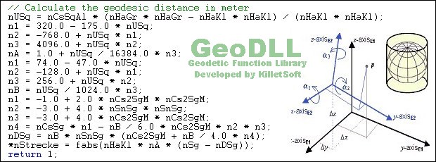
GeoDLL supports the development of geodetic software on various platforms by providing geodetic functions. GeoDLL contains precise calculations on the themes 2D and 3D coordinate transformation, geodetic datum shift and reference system converting, meridian strip changing, user defined coordinate and reference systems, distance calculations, Digital Elevation Model, NTv2 handling and BeTA2007 support, Direct / Inverse solutions, map function and geodetic converting functions. The most important application of GeoDLL is to include professional coordinate transformations in own programs. These coordinate and reference systems are supported: 1. The current and many historical coordinate and reference systems of all countries of the European Union (EU) including the eastern extensions and the systems of the European non-EU countries. 2. The European ETRS89 systems forced by INSPIRE with respect to the continental drift. 3 .The US and Canadian State Plane Coordinate Systems (SPCS) and other systems of the North American continent. 4. Many coordinate and reference systems of the countries of all continents and the world-wide used coordinate and reference systems. 5. World-wide NTv2 grid file supported coordinate transformations. 6. The coordinate and reference systems of the old and new German Federal States, the 40 Prussian Soldner Land Registers, the German 'Lagestatus', special reference systems of the German Federal States and BeTA2007. 7. User defined coordinate systems, reference systems and earth ellipsoids. GeoDLL comes with extensive documentation and is supplied as DLL file or as C++ source code for 32bit and 64bit architectures. The DLL works with most programming languages and it can be used with Microsoft Office programs. The DLL is written in C++ and was developed with Microsoft Visual Studio 2010. Thus very fast performance, compact code and high stability are assured. The functions of GeoDLL are prepared for multithreading.
development program, formula program, coordinate program, coordinates program, transformation program, conversion program

 Click here to start the download